Annotations
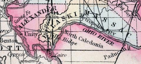
Pulaski County, Is., c. h. at Caledonia. In the Southern extremity of the state, between the Ohio and Mississippi. (Gazetteer of the United States of America, 1854)
PULASKI COUNTY, Is situated in the southern part of the state and contains about 180 square miles. The Ohio river, which separates it from Kentucky, forms its boundary on the south-east, and Cash river on the north-west. The surface is partly covered with forest, and the soil of the river bottoms is fertile. Corn, oats cattle and pork are the staples. It contains several churches, and has about 800 pupils attending public schools. It is intersected by the Illinois Central Railroad. Capital, Caledonia. Population, 5,700. (Hawes' Illinois State Gazetteer...,1859)
Demographic
Total Population 1850
2265
Total Population 1860
3943
Free Black Population 1860
39
Free Black Population 1850
8
Political
Presidential Election Result 1844
Democrat
Presidential Election Result 1848
Democrat
Presidential Election Result 1852
Democrat
Presidential Election Result 1856
Democrat
Presidential Election Result 1860
Douglas Democrat
Presidential Election Result 1864
Unconditional Union (1864)
Geographic
Latitude
37.215615
Longitude
-89.127755
Waterways
Yes
Railroads
Yes
Type
County
County
Pulaski
State
Illinois

