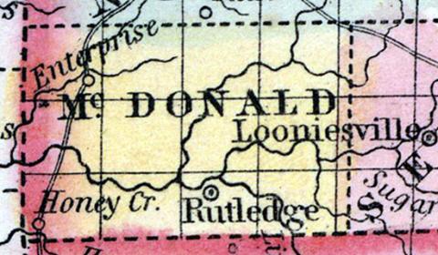
McDONALD COUNTY, situated at the southwest corner of Missouri. Area, --------- square miles. Seat of justice, Rutledge. Pop. in 1850, 2,236. (Fanning's, 1853)
McDONALD, a county forming the S. W. extremity of Missouri, bordering on Arkansas and the Indian Territory, has an area of 620 square miles. It is drained by the head streams of Elk or Cowskin river, an affluent of the Neosho. The slope of the county is towards the W. Indian corn, wheat, oats, cattle, and swine are the staples. In 1850 the county produced 145,659 bushels of Indian corn; 7839 of wheat; 7870 of oats, and 26,295 pounds of butter. It contained 5 churches. Elk river is bordered with forests of pine, and its branches furnish motive-power for mills. Lead mines are found in the county, but not yet worked. Named in honor of Sergeant McDonald, of South Carolina. Capital, Rutledge. Population, 2236, of whom 2153 were free, and 83, slaves. (Baldwin & Thomas, A New and Complete Gazetteer of the United States ... 1854)
McDONALD COUNTY This county is situated in the extreme southwestern corner of the State, bounded on the north by Newton County, on the east by Barry, on the south by Arkansas, and on the west by the Indian Territory, and contains an area of 648 square miles.
History.—The first settlements made here were in 1830, by Augustus J. Friend, P. Williams, R. Landerdale, Tiner, Mathews, Blevens, and Holcomb, whose families at that time numbered about forty souls. The county-seat was formerly at Rutledge, but is now at Pineville, which was once called Marysville, under which name it was first settled and located by J. B. King. In 1850 the population of the county was 2236; in 1856 it had increased to 3533; and in 1860, to 4061.
Physical Features.—The surface of the county is broken, and much of the upland sterile and unproductive for some crops, but good for fruit. The valleys are fertile, and well adapted to farming or stockgrowing purposes. The county is drained by Elk River, a tributary of the Arkansas, and by its tributaries, severally named Buffalo, Patterson's, Indian, Sugar, North Sugar, Battle, and Honey Creeks. Most of these streams are rapid, and afford excellent water power for mills or manufactories, which, when erected, would prove of great advantage to the community, and profitable to the proprietors. The timber consists of oak, walnut, pine, cedar, wild cherry, etc. Probably four-fifths of the county is timber land.... (Parker's Missouri as it is in 1867..., 1867)

