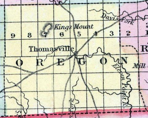
OREGON COUNTY, situated on the south boundary of Missouri. Area, -------- square miles. Seat of justice, Thomasville. Pop. in 1850, 1,432. (Fanning's, 1853)
OREGON, a new county in the S. part of Missouri, bordering on Arkansas, has an area of 1700 square miles. It is drained by the sources of the Eleven Points and Spring rivers, which flow south-eastward into the Big Black river. Indian corn, wheat, oats, hay, and cattle are the staples. In 1850 the county produced 69,201 bushels of corn; 2257 of wheat, and 5512 of oats. It contained 4 churches, and 86 pupils attending public schools. Capital, Thomasville. Population, 1432; of whom 1414 were free, and 18, slaves. (Baldwin & Thomas, A New and Complete Gazetteer of the United States ... 1854)
OREGON COUNTY This county is situated on the southern line of the State, was, until recently, one of the largest counties, as shown on old maps. It now contains but about eighteen townships. Population in 1860, 3448, Howell having been formed from the western part of it. A great proportion of the land is too rough and sterile for profitable cultivation—probably not over one-fifth being what can really be called fertile farming land. It was all naturally timber land, principally oaks, hickory, ash, and walnut; but the north part of the county embraces some fine large pine timber, which, to render available, must be sawed by steam-mills, there being no water power convenient.
The first settlement was made in 1803 by Charles Hatcher. The first settlers for a number of years were obliged to take their rare, peltries, and wild honey to Cape Girardeau, 135 miles distant, on horseback, and bring in return their goods by the same conveyance. Their nearest point to a river outlet now is Pocahontas, Arkansas, 55 miles, and to railroad, at Ironton, 110 miles.
This county is well adapted to fruit growing and grazing, as both soil and climate are favorable. Lead and copper ore has been found in the county, but no mines have been opened.
Churches and Schools.—There are 15 places of meeting in the county by the Methodist, Baptist, and Presbyterian denominations. Of schools, 16 free schools and 6 private are taught. Good teachers are much needed.
ALTON, the county-seat, is near the center of the county, and has fair prospects of becoming an important business point. Thomasville, on the head waters of the Eleven Point River; Lowassie, in the northeast corner; Engleside, in the east; Webster, in the southern; Warm Fork, in the southwest; and Jobe, in the southeast corner of the county, are all new towns. (Parker's Missouri as it is in 1867..., 1867)

