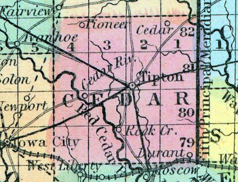
CEDAR COUNTY, situated in the eastern part of Iowa, and traversed by Cedar river. Area, ----- square miles. Seat of justice Tipton. Pop. in 1840, 1.253; in 1850, 3,941. (Fanning's, 1853)
CEDAR, a county in the E. part of Iowa, has an area of 676 square miles. It is intersected by the Cedar and Wapsipinicon rivers, and also drained by Sugar and Rock creeks. The surface is diversified by rolling prairies and woodlands; the soil is fertile and well watered, and the climate healthy. The staples are Indian corn, wheat, and butter. In 1850 this county produced 223,870 bushels of Indian corn; 81,876 of wheat, and 59,723 pounds of butter. The county is liberally supplied with timber. Cedar river, in the W. part of the county, flows through a narrow pass between high banks of perpendicular rock, affording abundant water power. Named from the Cedar river. Capital, Tipton. Population, 8941. (Baldwin's New and Complete Gazetteer of the United States..., 1854)
CEDAR COUNTY Was organized and settled in 1836. The county-seat, Tipton, was laid out in 1839. Present population of the town 583, and of the county 7605.
The towns and settlements in tbe county are Tipton, Woodridge, Cedar Bluffs, Pioneer P. O., Cedar P. O., Massillon P. O., Yankee Grove P. O., Red Oak P. O., Gower's P, O., Inland P. O., Springdale P. O., Padee P. O., Lacton P. O., and Rochester.
Three churches in Tipton — Presbyterian, Congregational, and Methodist, — society very good. Churcbes of different denominations throughout the county, but tbe precise number of church edifices or members not ascertained.
Four schools in Tipton — 2 public, 2 private. Average number of pupils in each, 30.
One steam grist-mill — doing but little business, owing to lack of water.
The Lyons R. R. is projected through the centre of this county, and mostly graded as far as Tipton, and we understand the suspended work on the line will be resumed energetically by the new company this season.
The county is made up of very excellent soil, adapted to all kinds of farming purposes, and well watered generally. Timber is less abundant in Cedar than in many other counties. Yet taken as a whole, Cedar holds out strong inducements to the farmer and mechanic, to locate within her borders. (Iowa As It Is in 1855; A Gazetteer for Citizens..., 1855)
CEDAR COUNTY Is in the second tier of counties west of the Mississippi River, and is bounded on the north by Jones, on the east by Clinton and Scott, on the south by Muscatine, and on the west by Johnson and Linn counties. It is watered by the Cedar river which, entering near the centre of the western boundary, passes out at the centre of the southern boundary, and by the Wapsipinicon, which flows through the north-eastern corner. These rivers are skirted by large belts of timber, and there are smaller groves upon their tributaries through the central portion of the county. The prairies are high and rolling, and the county is considered one of the best in the State for agricultural purposes, the soil being unsurpassed for richness and fertility, which, with a fair proportion, of timber, good water, and an inexhaustible supply of excellent building stone, easily quarried, along the banks of the several streams, has yielded to the industrious farmers of Cedar County, a bountiful supply of agricultural products, and afforded them comfortable and happy homes. It is a well known fact that the shipments of their surplus cattle, hogs and grain for the last two years, has given them an income as shown by the reports of the United States Assessor, greater than some of our supposed capitalists and wealthy merchants.
The Mississippi and Missouri Railroad runs through the south-east and south-west corners of the county, and the Chicago and Northwestern Railroad, through the northern tier of townships. The county contains sixteen townships: Cass, Centre, Dayton, Farmington, Fremont, Gower, Rochester, Inland, Iowa, Linn, Massilon, Pioneer, Red Oak, Springdale, Springfield and Sugar Creek. (Hair's Iowa State Gazetteer..., 1865)

