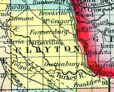
CLAYTON COUNTY, Iowa. Situated in the N. part of the Ter., and contains about 720 sq. ms. Drained by Turkey r. Navigable by steamboats to the junction of Volga r. These rivers afford good water power. Buck cr., Inymagill cr., Bloody run and Yellow r. flow into the Mississippi r., in its N. part. Some lead mines have been found. The land on Turkey r. is excellent. Capital, Prairie la Porte. There were in 1840, neat cattle 1,011, sheep 66, swine 941; wheat 1596 bush.produced, Ind. corn 23,270, oats 2,960, potatoes 14,000, sugar 13,529 pounds; 9 com. houses, cap. $78,300; 4 stores, cap. $1,500; 1 grist m. Cap. in manufac. $8,000. 2 sch. 25 scholars. Pop. 1,101. (Haskell's Complete Descriptive and Statistical Gazetteer of the the United States...,1840)
CLAYTON COUNTY Is the most northern river county in the State, except Alamakee. It is bounded on the east by the Mississippi, on the west by Fayette, on the south by Delaware and Dubuque. The principal water-courses in the county are Yellow and Turkey Rivers, Volga and Buck Creeks, and Bloody Bun. Turkey River is among the most beautiful and placid streams in the State, and is celebrated for its numerous geological specimens, and the picturesque scenery of its banks and dells. Turkey River affords most excellent water-power for mills and machinery, and is navigable the greater part of the year, as far up as the forks. The soil is about the same as in those counties adjoining, already described. The principal towns in the county are Garnaville, the county-seat, Brookville, Kilroy, Clayton, Guttenburg, Melville, Buena Vista, Elkport, Elkador, Farmersburg, and Brookville, besides several settlements, at each of which is a Post Office. (Iowa As It Is in 1855; A Gazetteer for Citizens..., 1855)

