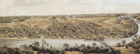
The city of Fredericksburg is in a handsome valley on the south side of the Rappahannock River, 56 miles from Washington City, and 62 miles from Richmond, on the line of the great southern rail-road. It is at the head of tide on the river, about 150 miles from its mouth. The Rappahannock is navigable for vessels of 140 tons, to the Falls of the Rappahannock, a short distance above the town…
Fredericksburg is regularly laid out, and compactly built; many of its buildings are of brick. The principle public buildings are a court-house, clerk’s office, and jail, a market-house, an orphan asylum, 1 Episcopal, 1 Presbyterian, 1 Methodist, 1 Baptist, and 1 Reformed Baptist church. The orphan asylum and a charity school are for females. The town also contains 2 banks, and 1 male and 1 female seminary of the higher class. It is supplied with water from the river, by subterraneous pipes; and is governed by a mayor and common council. A canal, extending from the town to Fox's Mill, a point on the Rappahannock 35 miles above, has been commenced and partly completed. Fredericksburg enjoys considerable trade, chiefly in grain, flour, tobacco, maize, &c., and considerable quantities of gold are exported. Its exports have been computed at over $4,000,000 annually. The Falls of the Rappahannock in the vicinity afford good water-power. There were in 1840, by the U. S. statistics, 73 stores, cap. $367,961; 2 tanneries, paints, drugs, &c., cap. $37,000; 1 grist-mill, 2 printing-offices, 4 semi-weekly newspapers; cap. in manufactures, $141,200; 5 academies, 256 students; 7 schools, 156 scholars. Population in 1830, whites 1,797, slaves 1,124, free blacks 387; total, 3,308. Population in 1840, 3,974.
Henry Howe, Historical Collections of Virginia… (Charleston, SC: William R. Babcock, 1852), 476, 479-480.

