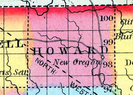
HOWARD, a new county in the N. N. E. part of Iowa, bordering on Minnesota, has an area of about 430 square miles. It is drained by the head streams of Turkey river, and the northern part is intersected by the Upper Iowa. The slope of the county is south-eastward. It contains extensive tracts of timber, interspersed with prairies. This county is not included in the census of 1850; county seat not located. (Baldwin's New and Complete Gazetteer of the United States..., 1854)
HOWARD COUNTY Is situated in the northern tier of counties, and the third west of the Mississippi River. It was organized in 1855.
The Turkey River heads in the centre of this county. The south fork of the Turkey or Crane Creek, as it is generally called, flows through the centre of the county in a very direct southeasterly course. It is a clear rapid stream, furnishing good water-power, which has been improved in many places. The Upper Iowa River pursues a winding course through the northern tier of townships running with a generally eastern direction. The southwestern portion of the county is imperfectly drained by the head waters of the Wapsipinicon, which flow through a level and rather marshy region; it is, however, through this low country quite heavily skirted with timber. The region between the valleys of the streams is gently rolling prairie, destitute of timber, which is generally confined to the edges of the streams. The soil is usually very fertile.
The McGregor Western Railroad, at present completed to Conover, in Winneshiek County, is located through this county, and it is expected will soon be in running order. (Hair's Iowa State Gazetteer..., 1865)

