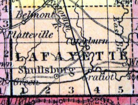
LAFAYETTE COUNTY, situated on the south boundary of Wisconsin. Area, -------- square miles. Seat of justice, ---------- . Pop. in 1850, 11,531. (Fanning's, 1853)
LAFAYETTE, a county in the S. S. W. part of Wisconsin, bordering on Illinois, has an area of about 660 square miles. It is drained by Fevre river, and the two branches of the Pekatonica, which cross the northern border of the county, and unite in the S. E. part. The surface is broken by ridges, which are in some parts entirely bare of timber, and in others covered with a sparse growth of oaks. The soil is generally productive. Wheat, Indian corn, oats, potatoes, pork, and lend are the staples. In 1850 this county produced 62,283 bushels of wheat; 91,491 of corn; 175,851 of oats, and 9196 tons of hay. It contained 18 churches, and 3203 pupils attending public schools. The cliff limestone which underlies the county abounds in rich veins of lead and copper, from which large quantities are taken. The famous Platte mounds, in the N. W. part, are remarkable for their regular form, and are surrounded by a large expanse of prairie. Organized in 1847. Capital Shullsburg. Population, 11,531. (Baldwin's New and Complete Gazetteer of the United States..., 1854)
LAFAYETTE, County, is bounded on the north by Iowa, on the east by Green, on the south by the State line, and west by Grant, and is 21 miles north and south, by 30 miles east and west. The country embracing the present county was set off by a division of Iowa county, and the formation of the counties of Lafayette and Montgomery, January 31, 1846, subject to the approval of the voters of said county, at the general election in September of the same year, at which election a majority voted against the "County Division Law." At the next session of the legislature, an act passed establishing the county of Lafayette, and it was organized February 4, 1847. The county seat has been a vexed question since the organization, but it has finally become established at the village of Shullaburg, a few miles southwest of the geographical centre. This county is more celebrated for its mining operations than for its agricultural products; simply, however, because the former has been prosecuted to the neglect of the latter. It is in connexion with the fifth judicial circuit, and the second congressional district, and forms the thirteenth senate district, and sends 3 members to the assembly, viz: 1. Towns of White Oak Springs, Benton and New Diggings. 2. Towns of Shullsburg, Monticello, Gratiot, Wayne and Wyota. 3. Elk Grove, Belmont, Kendall, Center, Willow Springs, Fayette and Argyle. The Peckatonnica and Fevre rivers are the principal streams. The population in 1847 was 9,335; 1850, 11,556. Dwellings, 2,079; farms, 399; manufactories, 21. County Officers for 1853 and 1854: County Judge, Jas. H. Knowlton; Sheriff, Peter C. Meloy; Clerk of Court, D. W. Kyle; District Attorney, Hamilton H. Gray; Register, Elias Slothower; Clerk of Board of Supervisors, Thomas McMannus; Treasurer, Ephraim Ogden; Surveyor, Thomas Bowen. (John Warren Hunt, Wisconsin Gazetteer..., Madison, 1853)

