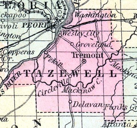
TAZEWELL, county, Ill. Situated a little N. of the centre of the state, and contains 1,130 sq. miles. Organized in 1827, from Peoria co.. Illinois r. runs on its s. w. border. Drained by Mackinaw r., and by branches of Sangamon r. The surface is level, or slightly undulating : soil, partly sandy prairie, and partly timbered with oak, and fertile. There are some swamps. Capital, Tremont. There were in 1840, neat cattle 7,785, sheep 5,422, swine 19,973; wheat 154,263 bushels produced, rye 1,844, Indian corn 423,751, buckwheat 1,203, barley 4,553. oats 73,630, potatoes 40,272, sugar 4,247 pounds; 14 stores, cap. $29,450; 1 tannery, 3 distilleries, 2 potteries, 2 flouring m., 5 grist m., 12 saw m. Cap. in manufac. $48,000. 4 acad. 191 students, 10 sch. 220 scholars. Pop. 7,221. (Haskell's Complete Descriptive and Statistical Gazetteer of the the United States...,1843)
TAZEWELL COUNTY, situated in the central part of Illinois, with Illinois river on the northwest. Area, 1,130 square miles, Illinois river on the northwest. Area, 1,130 squared miles. Seat of justice, Tremont. Pop. in 1830, 4,716; in 1840, 7,221; in 1850, 12,052. (Fanning's, 1853)
TAZEWELL COUNTY ls situated a little north-west from the centre of the state: has an area of 550 square miles. The Mackinaw creek flows through it from east to west until it enters the Illinois river, which forms the entire north-west boundary. The surface is nearly level and the soil fertile. The county contains large prairies, which are mostly under cultivation. Indian corn, wheat, oats, hay, pork and butter are the staples. It contains about 20 churches and about 2,960 pupils attending public schools. There is a railroad laid out through the county from Peoria to Bloomington. Capital, Tremont Population, 17,371. (Hawes' Illinois State Gazetteer...,1859)

