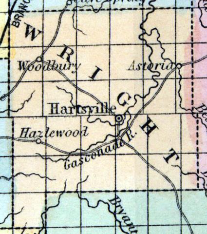
WRIGHT, a county in the S. part of Missouri, contains about 950 square miles. The Gasconade river and the Usage fork of the same rise in the county and flow northward; it is also drained by the sources of the James, Bryant's, Finley, and North forks of White river. The surface is uneven; a portion of the soil is productive. Indian corn, wheat, oats, cattle, pork, and butter are the staples. Peltry and beeswax are among the exports. In 1850 this county produced 194,695 bushels of corn; 82,730 of oats; 8631 of wheat, and 67,265 pounds of butter. It contained 1 church. The county is amply supplied with water-power. Lead, copper, and iron are said to be abundant in the vicinity of Hartsville, the county seat. Population, 3387; of whom 3306 were free, and 82, slaves. (Baldwin's New and Complete Gazetteer of the United States..., 1854)
WRIGHT COUNTY. This county is situated in the south central part of the State, bounded on the east by Texas, west by Webster, north by Laclede, and south by Douglas, and contains an area of about 500 square miles. The first settlements were made in 1838, at which time sixteen persons located here. Population in 1860, 4506.
Physical Features.—The surface of the county is in some portions hilly and broken, others moderately undulating. The Ozark range of hills pass in an east and west direction through the southern portion of the county, and some of the hills attain an elevation of 450 feet above the valleys of the streams. Along the Gasconade the hills are precipitous, and the scenery wild and picturesque. Principally covered with oaks and yellow pine. Good water-power on the Gasconade.
The Soils of the valleys and of the undulating uplands are fertile, and produce well, while those upon the cherty ridges are thin and generally sterile. The proportion of tillable upland is small, except for grapes and other fruits. On account of its high, dry, porous soils, and salubrious and healthy climate, some of the citizens have named it the "American Italy."
Products.—The most profitable products now marketed are stock, corn, wheat, tobacco, and hay. The present shipping point is Linn Creek. Marshfield will be the nearest railroad depot. Farmers have raised 1200 lbs. of hemp, 1200 lbs. tobacco, 75 bushels of corn to the acre, and grains, grasses, fruits, and vegetables in proportion.
Minerals.—Lead ore has been found both on the surface and in the rocks beneath, in sections 1, 2, 10, 11, 23, and 24, in township 29, range 12 west; and when the southwest branch of Pacific Railroad is completed (which passes near the north border of the county), these mines will doubtless be opened and prove profitable. Iron and copper have also been found, but no extensive explorations made.
HARTVILLE, the county-seat, is on Wood's Fork of the Gasconade, and though almost obliterated by the war, is rapidly being rebuilt by a new population. Mountain Grove is also a business center, 18 miles from Hartville. (Parker's Missouri as it is in 1867..., 1867)

