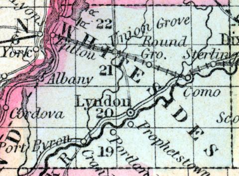
WHITESIDES, county, Ill. Situated in the N. W. part of the state, and contains 770 sq. miles. Formed in 1836 from Jo-Daviess co. Watered by Rock river and its branches. The surface is level or undulating; soil, fertile. Capital, Lyndon. There were in 1840, neat cattle 2,832, sheep 765, swine 6,751; wheat 27,206 bushels produced, Indian com 80,680, oats 26,886, potatoes 33,918, sugar 1,020 pounds; 12 stores, cap. $32,500; 4 grist m., 12 saw m. Cap. in manufac. $24,700. 8 sch. 194 scholars. Pop. 2,514. (Haskell's Complete Descriptive and Statistical Gazetteer of the the United States...,1843)
WHITESIDES COUNTY, situated on the northwest boundary of Illinois, with Mississippi river on the west, and traversed by Rock river. Area, 770 square miles. Seat of justice, Lyndon. Pop. in 1840, 2,514; in 1850, 5,361. (Fanning's, 1853)
WHITESIDE COUNTY. A county in the west-north-west part of the state. Has an area of about 700 square miles. It is bounded on the west by the Mississippi river, which separates it from Iowa. It is intersected by Rock creek. The county contains extensive prairies among which groves of timber are distributed. The soil is very productive. Indian corn, wheat, oats and hay are the staples. It contains several churches, and about 140 pupils attending public schools. Rock river furnishes valuable water power. The line of Mississippi and Rock River Junction railroad passes through the county. It was organized in 1839, and named in honor of Gen. Samuel Whiteside, who was distinguished as a captain of Rangers in the war of 1812. Capital, Sterling. Population, about 7,000. County Judge: Wm. M. Buckley, Sheriff: W. Shaffer. (Hawes' Illinois Gazetteer..., 1859)

