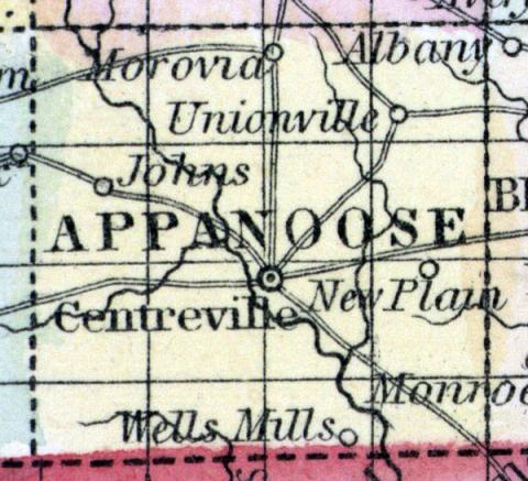
APPANOOSE COUNTY, situated on the south boundary of Iowa. Area ------ square mile. Courts are held at Centreville. Pop., in 1850, 3,131. (Fanning's, 1853)
APPANOOSE, a county in the S. part of Iowa, bordering on Missouri, has an area of 492 square miles. The Chariton river flows diagonally through the county, in a S. E. direction. The county is drained also by the S. fork of Chariton, and by Walnut and Cooper creeks. The surface is rolling or nearly level; the soil is fertile but mostly uncultivated. Indian corn, butter, and wool are the staples. In 1860 this county produced 80,930 bushels of Indian corn; 7893 of oats; 2337 pounds of wool; and 13,896 pounds of butter. Large beds of stone coal are found in several places. The county contains numerous prairies, and many of the streams are bordered by tracts of timber. Chariton rivor furnishes ample water-power. The county was first settled about the year 1845. Capital, Centreville. Population, 3131. (Baldwin's New and Complete Gazetteer of the United States..., 1854)
APPANOOSE COUNTY Is bounded on the east by Davis, on the west by Wayne, on the north by Monroe, and on the south by the Missouri line. Centreville, the county-seat, is the principal town in the county, and is situated on the Southern Iowa R. R., projected to run west from Fort Madison. The Chariton river passes in a south-easterly direction through the State, and upon its banks are numerous excellent mill-sites. Beside this, Shoal and Walnut Creeks, and the tributaries of the Chariton furnish water to every portion of the county. The soil is of an excellent quality, and the county tolerably well timbered. The climate is mild and pleasant, less subject to high winds than the middle and northern portion of the State. The principal towns in the county are Centreville, (the county seat), Sharon, Hibbsville, Unionville, and Iconium ; beside which are post-offices, named Moravia, Mount Gilead, New Plain, Cincinnati, Millard, Johns' and Pleasant View. (Parker's Iowa as it is in 1855..., 1855)

