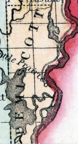
PEMISCOT, a county forming the S. E. extremity of Missouri, bordering on Arkansas and on the Mississippi river, which separates it from Tennessee, has an area estimated at 800 square miles. The surface is level, and mostly occupied by swamps and shallow lakes, among which the largest is Lake Pemiscot, situated in the S. part. Formed in 1851, out of the S. part of New Madrid county. Capital, Gayoso. (Baldwin & Thomas, A New and Complete Gazetteer of the United States ... 1854)
PEMISCOT COUNTY. This county is situated in the extreme southeastern corner of the State, bordering on the Mississippi River, which separates it from Tennessee, and touching on the Arkansas line on the south. Population in 1860, 3191.
Physical Features.—This county is in the district that suffered so much from the effects of the earthquakes of 1811 and 1812, and the numerous lakes spread over the county are left as "landmarks" of that unusual occurrence. The greater part of the county is subject to an annual overflow from the Mississippi River, but the citizens are building a levee which will protect them from this, and reclaim many thousand acres from inundation. The soil is fertile bottom land of an alluvial formation, heavily timbered with oaks, ash, elm, hickory, cottonwood, sycamore and cypress, and the climate as healthy as any section similarly situated. There are numerous mounds in various parts of the county, and in some instances they appear to have been built of stiff clay or sun-dried brick which have dissolved from the action of the elements, and now form a shapeless mass. From the number and regularity with which they are placed these may have been villages at some period centuries past.
Natural Resources.—We are indebted to George W. Carleton, Esq., of Gayoso, for the following information: "Iron is the only mineral found in the county. Professor Swallow, State Geologist, says that bog ore is abundant in Little River township, in western part of the county. We need flouring and grist mills. We have as good an agricultural district as can be found in any part of the Union. We have but very little waste land. All kinds of grain are produced here—wheat, oats, corn, rye, millet, etc. produce well. We have the best stock range in the world; our grasses are No. 1, the climate favorable, and the cattle look well, but we have no improved stock. Hogs fatten mostly in the woods. Farmers and stock growers are very much needed; we have very few if any real scientific, practical farmers, and I know that if our soil was tilled as it should be, it would produce double the quantity it now does. We can offer great inducements to the well-informed farmer or stock grazier. We have a good shipping point, and the produce can be sent to Memphis or New Orleans at trifling cost. We also want carpenters, joiners, brickmakers, brickmasons, blacksmiths, wagon-makers, and coopers. Send us any good, honest, industrious persons, and we guarantee they shall do well. Most of the lands in this county are subject to the annual inundations of the Mississippi River, but the levee will soon be completed, which will entirely remedy this."
History.—This section of country, it is supposed, was first settled as early as 1700 by Spanish colonies, and in the year 1800 by citizens from various parts of the United States. This country was almost depopulated by the terrible earthquakes of 1811 and 1812, which drove the citizens almost entirely out of it. Of those who were then inhabitants of this vicinity, we can learn of but two residing here now—Colonel John H. Walker and Nicholas Feror. A number of lakes were formed at that time by the settling of the earth's surface. The largest of which in this county is Lake Pemiscot, some five to eight miles wide from east to west, and twelve to fifteen miles long from north to south.
Churches and Schools.—The Methodists and Baptists have each churches in Pemiscot. There are twelve organized school districts, but one school-house in 1859, and one private school. Amount of school lands unsold in 1858 was 4160 acres; amount of school money appropriated in 1859 was $602.37. Number of children entitled to receive education in public schools, 758.
GAYOSO, the county-seat, is fifty miles from New Madrid, and five miles from Caruthersville, and was first settled by the French and Spaniards early in the present century. It contains a Baptist and a Methodist church, 1 hotel, 2 saw-mills, etc. Population about 250.
Caruthersville was first settled by Colonel John H. Walker, in 1805; is situated five miles from Gayoso, and contains 125 inhabitants.
Cottonwood Point, twenty miles from Gayoso, has 100 population, 1 church, several stores and mechanics' shops. Caruthersville and Solitude are villages. (Parker's Missouri as it is in 1867..., 1867)

