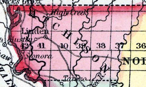
ATCHISON COUNTY, situated in the extreme northwest angle of Missouri, between Missouri and Nodaway rivers. Area --------- square miles. Courts are held at ----------- . Pop., in 1850, 1,687. (Fanning's, 1853)
ATCHISON COUNTY. This county is situated in the extreme northwestern part of the State, bounded on the west by the Missouri River, which separates it from Nebraska, and on the north by the Iowa State line. This is a new county, but was settled in 1840, and in 1850 contained a population of 1678; in 1856, 3304; and in 1860, 4663.
Physical Features, Soil, etc.—About one-half of the county is level and undulating, and the other half somewhat broken. About one-third is timber land, the remainder prairie. The soil is generally very fertile, and well adapted to farming and grazing purposes. Corn, wheat, oats, hemp, and tobacco are the principal products.
Inducements to Immigration.—Farmers and mechanics are much needed. There is a large amount of fertile land vacant, and 1460 acres of school lands unsold. Good water power unimproved upon the Nishnabotana, Tarkeo, and Rock Creek. Facilities for reaching market are offered by the Missouri River, which washes the western border of the county, and the Council Bluffs and St. Joseph Railroad is being built through the county.
ROCKPORT, the county-seat, is a brisk town of 800 population; Linden, 200; and Sonoro, 300 population. The seat of justice was moved from Linden to Rockport, in 1856. There is one newspaper in the county, "Rockport Weekly Herald." The county contains a number of churches, eighteen school-houses, a high school, Odd Fellow's Lodge, etc., and a good representation of business houses. (Parker's Missouri as it is in 1867..., 1867)

