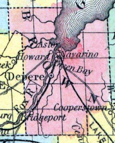
BROWN COUNTY, in the northeast part of Wisconsin, intersected by Depere. Area, 1,150 square miles. Seat of justice, Green Bay. Pop. 1840, 2,107; in 1850, 6,215. (Fanning's, 1853)
BROWN, a county in Wisconsin, situated at the head of Green bay, in the N. E. part of the state, contains 526 square miles. It is intersected by the Neenah or Fox river, and also drained by East and Centre rivers. The surface is diversified; the soil in some places is fertile. In 1850 the county produced 11,462 bushels of corn; 6212 of wheat; 17,674 of potatoes, and 2486 tons of hay. It contained 4 churches, 1 newspaper establishment, 860 pupils attending public schools, and 25 attending academies or other schools. The county was originally covered by dense forests. Measures have been taken, under the superintendence of the state, to render the Neenah navigable for steamboats. Brown county was organized in 1818, since which time its limits hare been greatly reduced by the formation of new counties. The seat of justice is established by law at Depere, but the courts are held for the present at Green Bay. Population, 6215. (Baldwin's New and Complete Gazetteer of the United States..., 1854)
BROWN, County, is bounded on the north by Oconto, on the east by Kewaunee, on the south by Manitowoc, and on the west by Outagamie, and a portion of Oconto. It derived its name from General Brown, commander-in-chief of the army, and was originally organized by an act of the legislative council of the territory of Michigan, approved 16th October, 1818, and then included all of the territory of the present state of Wisconsin, east of a line drawn due north from the northern boundary of Illinois, through the middle of the Portage between the Fox and Wisconsin rivers. Its limits have been decreased from time to time, until at present it contains only fourteen and a half townships, being 21 by 24 miles square, with an addition of 3 by 6 miles to its northwestern corner. The seat of justice is established by law at the village of Depere, on the Neenah, about eight miles from its mouth, although the courts are held, and most of the county business transacted at Green Bay. Its streams are: Fox, (Neenah), Manitoo, (or East), Ashwabena and Big Suamico rivers, and Duck creek. The soil is better adapted to grazing than the raising of grain, although it produces good crops of wheat, rye, oats, potatoes, &c. The surface is mostly level or slightly undulating, with but little swamp or waste land. It is mostly heavily timbered, with maple, beech, birch, &c, interspersed with pine and a good proportion of hemlock. Brown county is attached to the fourth judicial circuit, to the third congressional, and to the second senatorial district, and with Kewaunee and Door, forms an assembly district. The population in 1825 was 952; 1830, 964; 1836, 2,706; 1838, 3,084; 1840, 2,107; 1842, 2,146; 1846, 2,662; 1847, 2,914; 1850, 6,222. Farms, 267; manufactories, 23; and dwellings, 1,005. It must be borne in mind that new counties were established from the county of Brown, between nearly every taking of the census, and that the foregoing table, so far as showing the increase of population is concerned, is a very unsatisfactory one. The following are the county officers for 1853 and 1854: County Judge, David Agry; Sheriff, Orlo B. Graves; Clerk of Court, John Last; District Attorney, Baron S. Doty; Register of Deeds, E. Holmes Ellis; Clerk of Board of Supervisors, Wm. Field, Jr.; County Treasurer, Charles Henry; County Surveyor, Eli P. Royce; Coroner, David Cormier. (John Warren Hunt, Wisconsin Gazetteer..., Madison, 1853)

