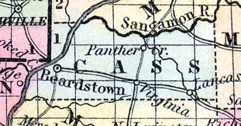
CASS COUNTY, situated toward the western part of Illinois, on the southeast side of Illinois river. Area, 256 square miles. Seat of justice, Virginia. Pop in 1840, 2,981; in 1850, 3,253. (Fanning's, 1853)
CASS COUNTY Is located in the central part of the state, and has an area of about 350 square miles. It is bounded on the north-west by the Illinois river, and on the north by the Sangamon river. These streams unite on the border of the county. The surface is nearly level, consisting of prairie and timber land; the soil is excellent. Wheat, corn, oats, hay and pork are the staples. The Illinois and Sangamon rivers are navigable by steamboats on the borders of the county. The Illinois River railroad, which is projected, will divide the county nearly in the center from north to south. The road is designed to connect Peoria with St. Louis direct. Capital, Beardstown. Population, 8,360. (Hawes' Illinois State Gazetteer...,1859)

