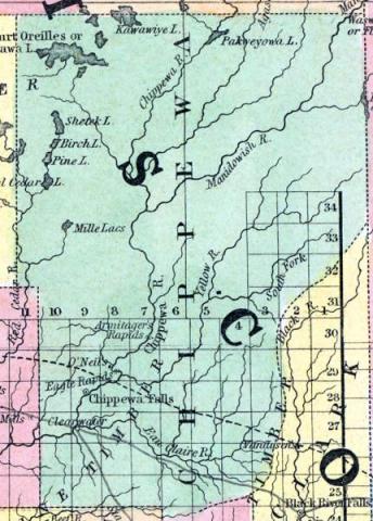
CHIPPEWA COUNTY, situated toward the northwest part of Wisconsin, on the northeast side of Mississippi river, and traversed by Chippewa river. Area, ---------- square miles. Pop. in 1850, 615. (Fanning's, 1853)
CHIPPEWA, a county in the N. W. part of Wisconsin, bordering on the Mississippi river, contains about 4300 square miles. It is traversed by the Chippewa river, and many large affluents. The surface is uneven, and mostly occupied by forests of pine and other trees. In 1850 the county produced 9522 bushels of wheat; 9656 of corn; 16,644 of oats, and 1302 tons of hay. The principal rock is sandstone. The county was formed in 1845. Capital, Chippewa Falls. Population, 614. (Baldwin's New and Complete Gazetteer of the United States..., 1854)
CHIPPEWA, County, is bounded on the N. by St. Croix and La Pointe, on the E. by Marathon, on the S. by La Crosse, on the S. W. by the Mississippi river, and on the W. by St. Croix. The southern boundary is rather indefinitely defined. It was established from Crawford, February 3, 1835, but has never been organized. Since the organization of La Crosse county, March 1,1851, the county and judicial connection has been changed from Crawford to La Crosse. The boundaries were somewhat changed January 14, 1846. Population in 1850 was 615. The soil in the western portion is good, in the northeastern less valuable, and covered with forests of excellent pine timber. It is watered by Chippewa river and its branches, and tributaries of Buffalo and Mississippi rivers. The tributaries of the Chippewa river are numerous, and pass through large portions of the county, watering lands as valuable as any in the State. There are now in successful operation 11 saw mills, capable of cutting 30,000,000 feet of lumber annually. The largest of these mills is owned by Allen, at Chippewa Falls; Menomonee, owned by Knapp, Williams & Taintor; and Carson & Eaton, at the mouth of the Eau Galla, which average about 5,000,000 of feet each, per annum, and furnish employment for about 200 hands each. The county seat was established by an act of the legislature, at the January session 1853, at Chippewa Falls, on Chippewa river. (John Warren Hunt, Wisconsin Gazetteer..., Madison, 1853)

