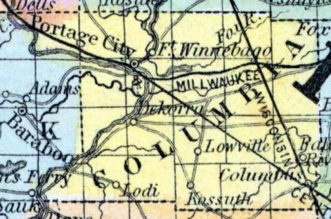
COLUMBIA COUNTY, situated toward the south part of Wisconsin, and traversed by Wisconsin river. Area, --------- square miles. Seat of justice, De Korra. Pop. in 1850, 9,565. (Fanning's, 1853)
COLUMBIA, a county in the S. central part of Wisconsin, contains 727 square miles. It is intersected by the Wisconsin and Neenah rivers, which at the Winnebago Portage are only about 1-1/2 miles apart. The surface is undulating or hilly, the soil fertile. Wheat, Indian corn, oats, potatoes, hay, and butter are the staples. In 1850 the county produced 169,309 bushels of wheat; 77,380 of Indian corn; 120,279 of oats; 13,497 tons of hay; and 168,370 pounds of butter. It contained 3 churches, 1 newspaper office, and 1951 pupils attending public schools. The Wisconsin is navigated by steamboats to the Winnebago Portage, and a canal connects it with the Neenah. Organized in 1846. Capital, Portage City. Population, 9565. (Baldwin's New and Complete Gazetteer of the United States..., 1854)
COLUMBIA, County, is bounded on the north by Adams and Marquette, on the east by Dodge, on the south by Dane, and on the west by Sauk; and is located mostly in the vicinity of the Portage of the Fox and Wisconsin rivers. It was set off from Portage and organized February 3, 1846. The boundaries were somewhat changed March 6, 1849. The streams of this county are: the Fox, (Neenah), Wisconsin, and Crawfish rivers, and Rocky Run, Ockie, Spring, and Duck creeks. For fertility of soil and feasibility of lands, the most of which are openings and prairie, this county is unsurpassed by any other in the State. It is connected with the third judicial circuit, and with the third congressional district, and constitutes the twenty-fifth senate district; sends two members to the assembly, being divided into the north and south assembly districts, nearly of the same size. The towns of Winnebago, Port Hope, Marcellon, Scott, Randolph, Portage, Prairie, Spring Vale, and Wyocena, forming the first; and the towns of Columbus, Fountain Prairie, Hampden, Otsego, Leeds, Lowville, Lodi, Dekorra, Westpoint, and Caledonia, the second district. The vote of the electors at the annual town meeting in April, 1851, permanently located the seat of justice at Fort Winnebago, in accordance with an act approved March 15, 1851. The population in 1846 was 1,969; 1847, 3,791; 1850, 9,563. Farms, 998; manufactories, 25; dwellings, 1,855. County officers for 1853 and 1854: County Judge, Joshua J. Guppy; Sheriff, Perry Lee; Clerk of Court, James Delany, Register of Deeds, William Owen; Clerk of Board of Supervisors, Alvin Alden; County Treasurer, H. Hascall; County Surveyor, John Thomas; Coroner, Isaac Smith. (John Warren Hunt, Wisconsin Gazetteer..., Madison, 1853)

