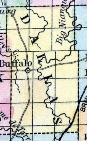
DALLAS COUNTY, situated toward the southwest part of Missouri. Area, --------- square miles. Seat of justice, Buffalo. Pop. in 1850, 3,648. (Fanning's, 1853)
DALLAS, a new county in the S. W. central part of Missouri, has an area of 576 square miles. It is intersected by the Niangua river, (an affluent of the Osage.) flowing from S. to N., and also drained by the head streams of the Little Niangua. The surface presents no great elevations, and consists of prairies and forests; the soil is generally good, and particularly adapted to pasturage. Indian corn, wheat, oats, cattle, and swine are the staples. In 1850 this county produced 187,580 bushels of corn; 8858 of wheat, and 65,796 of oats. There were 375 pupils attending public schools. The streams furnish valuable water-power, and the county is supplied with good springs of limestone water. Dallas county was formed a few years ago out of part of Polk county. Capital, Buffalo. Population, 3648, of whom 3500 were free, and 88, slaves. (Baldwin & Thomas, A New and Complete Gazetteer of the United States ... 1854)
DALLAS COUNTY This county is situated in the southwest central part of the State, bounded on the north by Camden and Hickory, south by Greene, east by Laclede and Webster, and west by Hickory and Polk Counties, and has an area of about 576 square miles. It is one of the new counties, and was formed from a portion of Polk. In 1850 it had a population of 3648; in 1856, 4620; and in 1860, 5914. The section now embraced in the county was first settled by J. H. Ross and others, in 1831.
Physical Features, Soil, etc.—Both the surface and the soil of this county are diversified. A portion of the county is level or undulating, and some parts quite broken. The prairies have generally a basis or "subsoil" of red clay, and upon experiment has proved to be well adapted to farming purposes. The timber-land is more rocky, but the soil is black and fertile, especially in the valleys. The ridges, which by many have been considered as barren and worthless, we find generally covered with wide-spreading arbors of native grape-vines, yielding largely of several varieties of wild grapes, which is conclusive evidence of their adaptation to grape and fruit culture. The timber consists principally of oaks, hickory, linn, maple, walnut, etc., etc. The county is drained by the Niangua River and its numerous lengthy, rapid tributaries.
Bryce's Spring, probably the largest in the State, is located near the Niangua, in township 34, range 18 west, near the line between Dallas and Laclede. "It rises in a secluded valley, where it forms a large basin, then flows away—a river." It is stated in the Geological Report that this spring discharges more than 126 cubic feet of water per second, 455,326 per hour, and 10,927,872 cubic feet per day. Lead ore has been found in several localities, and is worked upon township 29, range 19, and when the Pacific Railroad, southwest branch, is completed, affording a market, more attention will be given to mining as well as farming and stock growing.
Industrial Pursuits.—Of business houses and professions, there are in the county (principally in Buffalo) 1 newspaper, 2 lawyers, 3 doctors, 4 merchants, 1 druggist, 2 blacksmiths, 1 wagon-maker, 1 saddler, 1 tailor, 1 shoemaker, 1 cabinetmaker, 2 carpenters, and 3 hotels. There is 1 M. E. Church, with 50 members; and 23 free schools, besides the High School of Buffalo.
BUFFALO, the county-seat, is the principal town in the county. It has a population of about 200, a spicy newspaper, a high school, church, and many other indications of "the march of progress." Of other towns, there are Lewisburgh and Andersonville, with about 50 population each. (Parker's Missouri as it is in 1867..., 1867)

