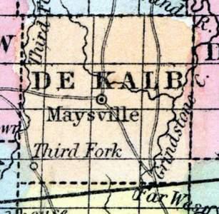
DE KALB COUNTY, situated In the northwest part of Missouri. Area, -------- square miles. Seat of justice, Maysville. Pop. in 1850, 2,076. (Fanning's, 1853)
DE KALB, a new county in the N. W. part of Missouri, has an area of 441 square miles. It is drained by Blue and Grindstone creeks, affluents of Grand river, and by Livingston creek, and the Third fork of Platte river. The surface is diversified by prairies and woodlands; the soil is productive. Indian corn, wheat, oats, hay, butter, and pork are the staples. In 1850 this county produced 103,865 bushels of corn; 11,731 of wheat; 13,547 of oats; 108 tons of hay, and 30,375 pounds of butter. De Kalb was formed out of part of Clinton county. Capital, Marysville. Population, 2075, of whom 2010 were free, and 65, slaves. (Baldwin & Thomas, A New and Complete Gazetteer of the United States ... 1854)
DE KALB COUNTY This county is situated in the northwest portion of the State, bounded on the north by Gentry, south by Clinton, east by Daviess, and west by Andrew and Buchanan Counties. The county was formed from a portion of Clinton County, in 1841, and the post-office at the county-seat established in 1845. Population of the county in 1850, 2075; and in 1860, 5244.
Soils, Productions, etc.—The soils of this county are fertile and well adapted to the growth of hemp, corn, wheat, tobacco, etc. Hemp is regarded as the most profitable crop—yielding from 1000 to 1500 pounds to the acre, which cost $16 per acre to raise and prepare for market, and is worth $90 per ton ready for shipment . Small grains yield abundantly; horses, mules, cattle, and sheep, do well, and stock raising is profitable. Building stone, clay for bricks, and hardwood timber, abundant. The general surface is undulating, and diversified by prairies and woodlands. The Hannibal and St. Joseph Railroad passes through the southern border of the county, affording cheap and speedy transit to the best of markets, at St . Joseph, St. Louis, or Chicago.
MAYSVILLE, the county-seat, is situated east of the center of the county, upon the table-lands, between Livingston Creek, which bears south into the Platte, and Grindstone Creek, which runs north, into Grand River. It contains 4 churches, Campbellite, Cumberland Presbyterian, Methodist, and Missionary Baptist—a Masonic Lodge, High School, and 350 inhabitants.
Stewartsville is a brisk new town, situated on the Hannibal and St. Joseph Railroad, twenty-one miles from St. Joseph; contains 1 newspaper office, 1 Methodist and 1 Presbyterian church, Masonic Lodge, and about 600 inhabitants.
Third Fork is situated upon a tributary of the Platte, of the same name, fourteen miles from Maysville, and is one of the oldest towns in the county, having been settled in 1837. It is connected by stage with Gentryville, 23 miles; Albany, 30 miles; Tolo, 15 miles, Rochester, 7, and St. Joseph, 21 miles. (Parker's Missouri as it is in 1867..., 1867)

