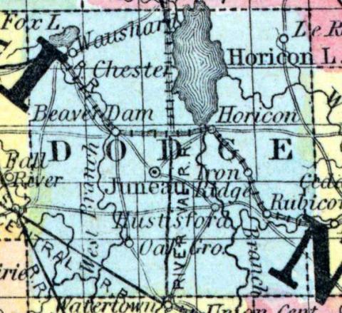
DODGE COUNTY, situated toward the easterly part of Wisconsin. Area, 756 square miles. Face of the country level, with prairies and swamps. Pop. in 1840, 67; in 1850, 3,892. (Fanning's, 1853)
DODGE, a county in the S. E. central part of Wisconsin, contains 936 square miles. It is intersected by Rock river and by Crawfish and Beaver Dam creeks. The surface is diversified by prairies and "oak openings," or uplands, which are covered with a scattered growth of burr and pin oaks, while the large streams are bordered by dense forests of oak, ash, elm, maple, &c. The soil is calcareous, and very fertile; the Winnebago marsh, (an immense mill pond, through which Rock river flows,) covers an area of 44 square miles. Wheat, Indian corn, oats, potatoes, pork, and butter are the staples. In 1850 the county produced 327,936 bushels of wheat; 127,672 of Indian corn; 204,197 of oats; 168,228 of potatoes, and 331,246 pounds of butter. There were 10 churches, and 3248 pupils attending public schools. Limestone, suitable for building, is found in considerable quantities. It is intersected by the Fond du Lac and Chicago, railroad. Rock river furnishes valuable motive-power, and is navigable for small boats. This is one of the most populous and flourishing counties of the state. Named in honor of Henry Dodge, first governor of Wisconsin. Capital, Juneau. Population, 19,138. (Baldwin's New and Complete Gazetteer of the United States..., 1854)
DODGE, County, is bounded on the north by Marquette and Fond du Lac, on the east by Fond du Lac and Washington, on the south by Waukesha and Jefferson, and on the west by Dane and Columbia; and is 30 miles square. It was so named in honor of General Dodge, first Governor of the territory, and was set off from Brown, December 7, 1836, to which it remained attached for judicial purposes until January 13,1840, when it was organized for county purposes, and its judicial connection changed to Jefferson. It was fully organized Jan. 20, 1844. The seat of justice is at the village of Juneau, formerly known as Dodge Centre. The surface of the country, west of Rock river, is diversified with openings, prairie, and good hay marsh; and the soil being good, it is well adapted to the raising of wheat and the summer grains, and to grazing. East of the river it is timbered with a heavy growth of maple and other hard woods, and the soil produces the grain crop with equal advantage with the other side, while it is more naturally adapted to the growth of the cultivated grasses. Near the banks of Rock river are beds of iron ore, which are successfully worked. Dodge county forms a part of the third judicial circuit, and of the third congressional district, and constitutes the twenty-second senate district. It is divided into six assembly districts, as follows: 1. Towns of Leroy, Lomyra, "Williamstown and Theresa. 2. Towns of Hubbard, Hennon, Hustisford and Rubicon. 3. Towns of Emmet, Lebanon and Ashippun. 4. Towns of Elba, Lowell, Clyman, Portland and Shields. 5. Towns of Fox Lake, Trenton, Westford, Calamus and Beaver Dam. 6. Towns of Chester, Burnette and Oak Grove. It is watered by the Crawfish, Rock and Beaver Dam rivers, and their tributaries. The population in 1838 was 18; 1840, 67; 1842,149; 1846, 7,787; 1847,14,905; and 1850, 19,140. Dwellings, 3,561; farms, 2,338; manufactories, 30. County Officers: County Judge, S. L. Rose; Sheriff, Benj. Ferguson; Clerk of Court, J. B. Ribble; Register of Deeds, N. Juneau; Clerk of Board of Supervisors, E. Sweeney; County Treasurer, L. Merz. (John Warren Hunt, Wisconsin Gazetteer..., Madison, 1853)

