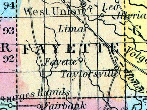
FAYETTE, a new county in the N. E. part of Iowa, has an area of 720 square miles. The Turkey river, an affluent of the Mississippi, is formed in the N. part by the union of its two main branches, and then traverses the N. E. part of the county; the South fork of the same stream drains the middle portion; the S. part is drained by Buffalo and other creeks. The surface is undulating, and extensively covered with woods, among which are scattered numerous fertile prairies. The climate is healthful. In 1800, Fayette county produced 5000 bushels of Indian corn; 485 of wheat, and 183 tons of hay. The streams of this county are said to afford extensive water-power. Capital, West Union. Population, 825. (Baldwin's New and Complete Gazetteer of the United States..., 1854)
FAYETTE COUNTY Is bounded on the east by Clayton County, which separates it from the Mississippi, on the north by Winnesheik, on the west by Chickasaw and Bremer, and on the south by Buchanan. The county is well watered by Turkey River, and its north and south forks, and various other tributaries. The soil is admirably adapted for all agricultural purposes. The scenery along Turkey River and its north and south forks is beautiful, and timber abundant. The Minnesota Railroad, projected to run north-west from Dubuque, passes diagonally through this county, and when built will add greatly to its wealth and importance. The principal towns in the county are West Union, the county-seat, Lima, and Taylorsville, besides post offices named Eldorado, Eden, Clermont, Douglas, Windsor, Louisville, Gamble Grove, Illyria, Fayetteville and Mill Grove. (Iowa As It Is in 1855; A Gazetteer for Citizens..., 1855)

