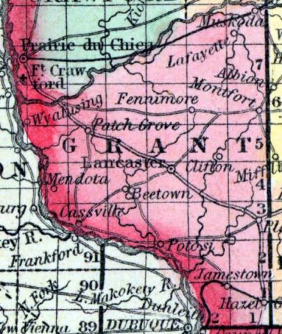
GRANT COUNTY, situated at the southwest corner of Wisconsin, with Mississippi river on the southwest, and the Wisconsin on the northwest. Face of the country generally level, or undulating; soil productive. Seat of justice, Lancaster. Pop. in 1840, 3,926; in 1850, 9,107. (Fanning's, 1853)
GRANT, a county forming the S. W. extremity of Wisconsin, bordering on Illinois and Iowa, has an area of 1224 square miles. The Mississippi forms its boundary on the B. W., and the Wisconsin on the N. W. It is drained also by the Platte, Grant, Blue, and Fevre rivers. The surface is diversified by prairies and woodlands, and presents a succession of ridges and valleys: the former consist of limestone, and are traversed by fissures which contain an abundance of lead and zinc. The soil is excellent and particularly adapted to wheat. In 1850 the county produced 127,164 bushels of wheat; 200,585 of Indian corn: 204,666 of oats; 8834 tons of hay, and 113,946 pounds of butter. It contained 14 churches, 1 newspaper office; 4174 pupils attending public schools, and 120 attending academies and other schools. The southern part of the county is represented as one vast lead mine, which has produced more than six million pounds of lead in a year. The county is liberally supplied with water-power. It is intersected by the Mississippi and Milwaukee railroad, not yet finished. Organized in 1836. Capital, Lancaster. Population, 16,169. (Baldwin's New and Complete Gazetteer of the United States..., 1854)
GRANT, County, is bounded on the northwest and north by the Wisconsin river, which separates it from Crawford and Richland, on the east by Iowa and Lafayette, on the south by the northern line of the State of Illinois, and on the southwest by the State of Iowa, from which it is separated by the Mississippi river. It was set off from Iowa, and fully organized by an act approved Dec. 7,1836. The eastern boundary extends north, on the 4th principal meridian, about 50 miles. The southern boundary on Illinois river is only about 10 miles, and its river coast is about 100 miles in length. The seat of justice is at Lancaster, near the centre of the county. Its principal streams are Grant, Big and Little Platte, Greene and Blue rivers. The surface of the country consists of a series of ridges, high rolling prairie and timbered lands. The ridges are filled with fissures, which are abundantly supplied with ores of zinc, lead, and occasionally copper. It is one of the best mineral counties in the State, and there is no other in which the soil is better adapted to the raising of wheat and corn. The county is well supplied with timber, and has many fine streams abounding in springs of pure water. It is said that there is neither lake, swamp, nor stagnant pool of water in the county. It is attached to the fifth judicial circuit, and to the second congressional district, and constitutes the 16th senate district, and sends five members to the assembly, as follows: 1. Towns of Hazel Green, Jamestown and Smeltzer. 2. Towns of Paris, Ptosi and Harrington. 3. Towns of Platteville, Lima, Clifton, Muscoda and Wingville. 4. Towns of Fennimore, Ellenboro', Liberty and Lancaster. 5. Towns of Waterloo, Beetown, Patchgrove and Cassville. The population in 1838 was 2,763; 1840, 3,926; 1842, 5,937; 1846, 12,034; 1847, 14,016; 1850, 16,169; 2861 dwellings, 707 farms, 78 manufactories. County Officers for 1853 and 1854: Judge, Cyrus K. Lord,; Clerk of Court, A. W. Kendall; District Attorney, J. Allen Barber; Register, George H. Cox; Clerk of Board of Supervisors, Wood A. Beach. (John Warren Hunt, Wisconsin Gazetteer..., Madison, 1853)

