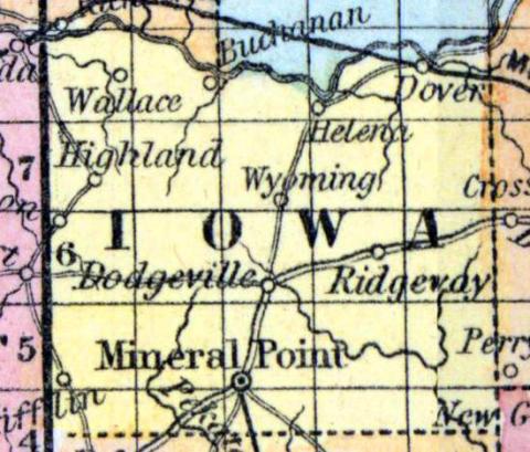
IOWA COUNTY, situated toward the southwesterly part of Wisconsin, with Wisconsin river on the north. Area, 1,300 square miles. Seat of justice, Mineral Point. Pop. in 1830, 1,576; in 1840, 3,978; in 1850, 5,672. (Fanning's, 1853)
IOWA, a county in the S. W. part of Wisconsin, contains 740 square miles. The Wisconsin river bounds it on the N., and it is drained by the branches of the Pekatonica, which rise in the county and flow south-eastward. The surface is occupied by valleys and ridges, which are mostly destitute of timber, excepting small and scattered groves. The soil is calcareous and fertile. Wheat, Indian corn, oats, and wool are the staples of agriculture. In 1850 the county produced 50,747 bushels of wheat; 81,108 of Indian corn; 109,875 of oats; and 53,090 pounds of butter. It contained 13 churches; 1664 pupils attending public schools, and 85 attending academies or other schools. This county is remarkable for mineral wealth. Lead is abundant, and is one of the chief articles of export. Copper and zinc are also found in connection with the lead. The county is intersected by the Milwaukee and Mississippi railroad, not yet finished. Capital, Mineral Point. Population, 9525. (Baldwin's New and Complete Gazetteer of the United States..., 1854)
Iowa, County, is bounded on the north by Richland and Sauk, on the east by Dane and a portion of Green, on the south by Lafayette, and on the west by Grant. It. was formed from Crawford by an act of the legislative assembly of Michigan October 9, 1829, at which time it included all of the present State of Wisconsin, south of the Wisconsin river, and west of "a line drawn due north from the northern boundary of Illinois, through the middle of the Portage between the Fox and Wisconsin rivers." On the 6th September, 1834, the southern boundary of Iowa county was changed to the line between the Green Bay and Wisconsin land districts, which was a north and south line from the northern boundary of Illinois along the range of township line next west of Fort Winnebago, to the Wisconsin river, on the range line between ranges 8 and 9. The seat of justice is at Mineral Point. It is watered by branches of the Peckatonnica river, Blue river, and Mineral and Pipe creeks. The county contains about 750 square miles, and is eminently a mining county, but is also equally valuable for its agricultural resources. The soil is not surpassed in fertility by any in the State. Prairie and timber land in about equal proportions. The wheat or corn crop along the Wisconsin river never fails. The population is composed of Americans, Germans, English, Welsh, and Irish. The whole northern portion of the county, to a distance of eight or ten miles from the Wisconsin river, is peculiarly an agricultural country, and unsurpassed for stock raising. South from this, the mineral region extends in every direction, over prairie and woodland. The central and southern portion of the county is a mining country, but none the less adapted to farming—for its rich soil and abundant water render any part of it attractive. Prairie and timber alternately predominate. Streams of water meander through every ravine, furnishing not only irrigation for the land but a large quantity of water power. The ague and fevers of the West are unknown here. The advantages of this county are briefly, health, mineral wealth, agricultural resources, and abundant water power. The railroad to State line and connection with Chicago will give the settlers here a constant market. This county is connected with the fifth judicial circuit, the second congressional district, and, with Richland, forms the fifteenth senate district. It is divided into two assembly districts: 1. Towns of Highland, Dodgeville, Ridgway, Arena, Wyoming, Pulaski, and Clyde. 2. Towns of Mineral Point, Mifflin, Lyndon and Waldwick. The population in 1830 was 1,589; 1836, 3,218; 1838, 5,234; 1840, 3,978; 1842, 5,029; including Richland—1846, 14,905; 1847, 7,963; 1850,10,479. County Officers for 1853 and 1854: County Judge, Parley Eaton; Sheriff, H. N. Mumford; Clerk of Court, James Hutchinson; Clerk of Board of Supervisors, James B. Gray; Register of Deeds, N. B. Boyden; County Treasurer, John B. Uren; District Attorney, Amasa Cobb; County Surveyor, Henry Madden. (John Warren Hunt, Wisconsin Gazetteer..., Madison, 1853)

