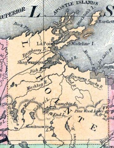
LA POINTE, a county forming the N. W. extremity of Wisconsin, bordering on Minnesota and Michigan, has an area of 5330 square miles. Lake Superior washes its northern border. The St. Croix and Chippewa rivers rise in the county and flow into the Mississippi; the Burntwood and Mauvais rivers also rise in the county and flow into Lake Superior. The surface is extensively covered by forests of pine timber. In 1850 this county produced 250 bushels of corn; 233 of oats, 1950 of potatoes, and 45 tons of hay. Thirty pupils attended public schools. Capital, La Pointe. Population, 489. (Baldwin's New and Complete Gazetteer of the United States..., 1854)
LA POINTE, County, is bounded on the northwest and north by the State line, in Lake Superior, on the east by Marathon, on the the south by Chippewa and St. Croix, and west by Minnesota. It was set off from St. Croix Feb. 19,1845. It was, and remained attached to Crawford for judicial purposes, until the complete organization of St. Croix, Feb. 26,1849. The boundaries were changed 6th March 1849, and it was fully organized 9th Feb. 1850. The county seat is established at La Pointe, on the southeast end of Madeline Island, in Lake Superior, the oldest settlement in the State. The county is watered by Bois Brule, (Burnt Wood,) Mauvais, (Bad,) or Maskau rivers, and other small streams entering the lake from three to ten miles apart, and by lakes. The country, for a short distance along the margin of the lake, is low and wet; further south it is generally rolling. The western portion of the country is prairie land; and the soil being good and winters mild, offers great inducements to agriculturists. In the more eastern parts, the timber in most places is very thick, comprising white and yellow Norway pine, and the different species of oak, maple, birch, and the soft woods. The county is in connexion with the nineteenth senate district, the sixth judicial circuit, and the second congressional district, and with St. Croix sends one member to the assembly. French missionaries visited this country as early as 1661. In 1850 the population was 489; 5 farms and 74 dwellings. R. D. Boyd is Register of Deeds, and Clerk of the Circuit Court and of the Board of Supervisors. (John Warren Hunt, Wisconsin Gazetteer..., Madison, 1853)
Note: La Pointe County was renamed Bayfield County in 1866.

