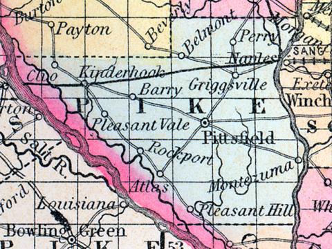
PIKE COUNTY, situated on the southwesterly boundary of Illinois, with Mississippi river on the southwest and the Illinois on the east. Area, 800 square miles. Seat of justice, Pittsfield. Pop. in 1830, 2,396; in 1840, 11,728; in 1850, 9,095. (Fanning's, 1853)
PIKE COUNTY Is situated in the west part of the state, bordering on Missouri, and has an area of 750 square miles. It extends from the Illinois river, on the east, to the Mississippi, which forms its south-western boundary. It is traversed by a side channel of the Mississippi, called Snycartee slough, and also drained by McKee's bay and Little Muddy creeks. The surface is rolling, and consists of prairies and forests, the proportions of which are nearly equal. The soil is extremely fertile, and extensively cultivated. Corn, wheat, oats, potatoes, pork and butter, are the staples. It contains about 25 churches, several newspaper offices, and has about 4,000 pupils attending public schools. Stone coal is abundant, and the rivers afford excellent facilities for exporting the various articles of produce to northern and southern markets. An extension of the Great Western railroad is being built, which will change materially the appearance of the county. Capital, Pittsfield. Population, about 28,000. County Judge, A. Grubb. (Hawes' Illinois State Gazetteer...,1859)

