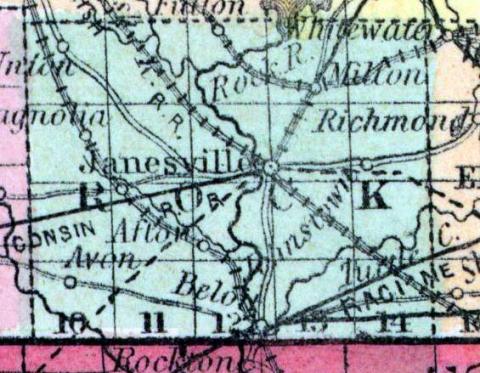
ROCK COUNTY, situated on the south boundary of Wisconsin, and traversed by Rock river. Area, -------- square miles. Face of the country, even; soil, rich. Seat of justice, Janesville. Pop. in 1840, 1,701; in 1850, 20,708. (Fanning's, 1853)
ROCK, a county in the S. part of Wisconsin, bordering on Illinois, contains about 770 square miles. It is traversed from N. to S. by Rock river, into which several large streams empty. The surface is undulating, and the soil highly productive. Rock Prairie, the largest in the state, occupies nearly half of the county, extending from the river eastward. The staples are wheat, maize, oats, wool, potatoes, pork, and butter. In 1850 the county produced 784,278 bushels of wheat; 300,143 of Indian corn; 487,880 of oats, and 410,881 pounds of butter. It contained 17 churches, 3 newspaper offices; 5186 pupils attending public schools, and 194 attending academies and other schools. The most abundant rock of the county is the blue limestone. Rock river is a fine stream flowing through a valley remarkable for beauty and fertility, and affording abundant water-power. The public improvements are the Fond du Lac and Rock River railroad, the Beloit and Madison railroad, the Racine and Janesville railroad, and the Milwaukee and Mississippi railroad. Organized in 1839, and named from its principal stream. The settlement began in 1836, and has progressed with great rapidity. Capital, Janesville. Pop., 20,750. (Baldwin's New and Complete Gazetteer of the United States..., 1854)
ROCK, County, is bounded on the north by Dane and Jefferson, on the east by Walworth, on the south by the State of Illinois, and on the west by Green. The county seat is at Janesville, on Rock river. It was set off from Milwaukee, Dec. 7,1836, and fully organized Feb. 19, 1839. The county is about equally divided between prairie and oak openings, with no large bodies of heavy timber. It is situated on both sides of Rock river, the valley of which is as rich soil as can be found in any part of the country. The prairies are some of them quite large, but beautifully undulating, and productive in the highest degree, and are being settled and cultivated to the very centre. The different varieties of soil—upland, bottom land, prairie and openings, afford facilities for cultivating all the productions of the climate to the greatest advantage— wheat upon the rolling prairies and openings—the coarser grains upon the bottom lands—and tame and wild grasses upon the low prairies and marshes, flourish best, though each class of soil is adapted more or less to all these products. It is watered by Rock river and its branches. The principal villages are Janesville, Beloit, Fulton, and Milton. The county is in connection with the first judicial circuit, the second congressional district, and is entitled to the following representation:—17th Senate district, consists of the towns of Rock, Fulton, Porter, Centre, Plymouth, Newark, Avon, Spring Valley, Magnolia, and Union.—18th Senate district, consists of the towns of Beloit, Turtle, Clinton, Bradford, La Prairie, Harmony, Johnstown, Lima and Milton.—1st Assembly district, Beloit, Turtle and Clinton.—2d Assembly district, Milton, Harmony, Lima, Johnston, Bradford, and La Prairie.— 3d Assembly district, Janesville, Rock Centre, and Fulton.— 4th Assembly district, Porter, Union, Magnolia, Spring Valley, Plymouth, Newark and Avon. Its population in 1840 was 1,701; 1842,2,867; 1846,12,405; 1847,14,720; 1850, 30,717. Square miles, 720. It has 3,631 dwellings, 1,975 farms, and 126 manufactories. County Officers for 1853 and 1854: Judge, James Armstrong; Clerk of Court, George W. Crabb; Sheriff, William H. Howard; District Attorney, Wm. S. Rockwell; Clerk of Board of Supervisors, C. P. King, Register, Samuel A. Martin; Treasurer, Robert F. Frazer; Coroner, Calvin Chapin. (John Warren Hunt, Wisconsin Gazetteer..., Madison, 1853)

