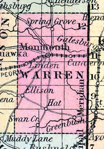
WARREN, county, Ill. Situated in the W. toward the N. part of the stale, and contains 900 sq. ms. Formed in 1825, organized in 1830. Mississippi r. bounds it on the W. Drained by Henderson r. and its branches, and by Ellison, Honey, and Camp creeks. The surface is level; soil very fertile, particularly on the streams. On the Mississippi it is liable to submersion. Capital, Monmouth. There were in 1840, neat cattle 9,769, sheep 7,141, swine 23,682; wheat 75,243 bush. produced, rye 4,120, Indian corn 293,813, barley 1,394, oats 97,400, potatoes 21,884, sugar 22,619 pounds; 2 commission houses, cap. $4,000, 10 stores, cap. $29,500; 1 tannery, 1 distillery, 3 flouring m., 4 grist m., 20 saw m. Cap. in manufac. $79,370. 19 sch. 569 scholars. Pop. 6,739. (Haskell's Complete Descriptive and Statistical Gazetteer of the the United States...,1843)
WARREN COUNTY, situated in the west part of Illinois. Area, 600 square miles. Seat of justice, Monmouth. Pop. in 1830, 308; in 1840, 6,739; in 1850, 8,176. (Fanning's, 1853)
WARREN COUNTY A county in the west part of the state, has an area of 650 square miles. It is traversed by the Henderson river, and is also drained by Ellison and Swan creeks. The surface is nearly level, and the soil highly productive. The county contains prairie, and is liberally supplied with timber. Indian corn, wheat, oats, hay, wool and pork, are the staples. It contains several churches, and has 500 pupils attending public schools. Stone coal and lime stone are the most valuable minerals of the county. It is intersected by the Military Tract railroad, and by the Peoria and Oquawka railroad. Capital, Monmouth. Population, about 9,000. (Hawes' Illinois State Gazetteer...,1859)

